| The Fish Net Weather | |||
|---|---|---|---|
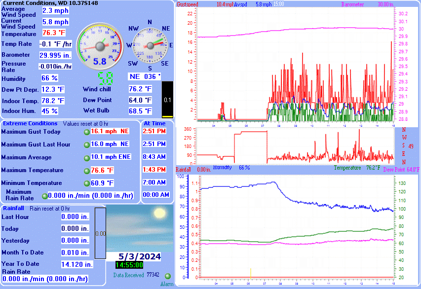
| LAST READING AT TIME: 5:15 PM DATE: July 21 2026, time of next update: 5:30 pm | |||
| Current Weather | Dry | Current Temperature | 83.7°F (28.7°C) (Heat Index 94.6°F ), Apparent temp 91.7°F |
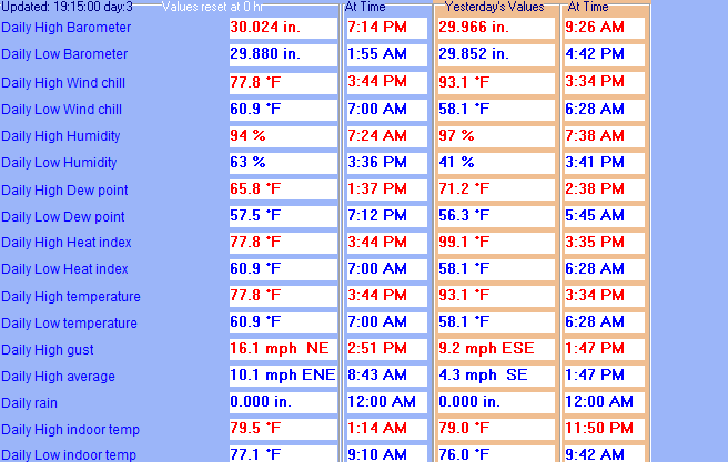
| Maximum Temperature (since midnight) | 90.4°F at: 1:32 PM | Minimum Temperature (since midnight) | 73.9°F at: 4:04 AM |
| Average windspeed (ten minute) | 1.5 mph | Wind Direction (ten minute) | S (169°) |
| Heat Index | 94.6°F | Maximum Gust (last hour) | 8.0 mph at: 5:03 PM |
| Maximum Gust (since midnight) | 8.1 mph at: 5:03 PM | Maximum 1 minute average (since midnight) | 4.4 mph at: 5:08 PM |
| Rainfall (last hour) | 0.000 in. (0.0 mm) | Rainfall (since midnight) | 0.000 in. (0.0 mm) --- |
| Rainfall This month | 3.61 in. (91.7 mm) | Rainfall To date this year | 22.110 in. (561.6 mm) |
| Maximum rain per minute (last hour) | 0.000 in/min | Maximum rain per hour (last 6 hours) | 0.000 in/hour |
| Yesterdays rainfall | 0.000 in | DewPoint | 78.0°F (Wet Bulb :79.6°F ) |
| Humidity | 83 %, Humidex 107.0°F | Barometer corrected to msl | 29.671 in. (1004.8 hPa) |
| Pressure change | 0.00 in. (last hour) | Trend (last hour) | STEADY |
| Pressure change (last 12 hours) | -0.11 in | Pressure change (last 6 hours) | -0.08 in |